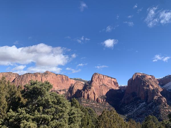
Kolob Canyon
Kolob Canyon, which easily connects with The Kolob Terrace, is one of Klay Klemic’s favorite areas of Zion National Park. Not only is it just a few miles away from Rising K Ranch, but it is full of Zion’s higher elevation types of terrain, with quaking aspen tall pine, and plenty of flowing water all year long.
In Kolob Canyon, the Navajo Sandstone rises in monoliths, called “The Fingers of Kolob Canyon”, which are thousands of feet high and bright red in color. Especially at sunset, Kolob Canyon is one of Zion’s most beautiful sights!
In Kolob Canyon, most of the hiking trails are quite short, though there are some hiking/horseback riding trails that will take you all the way to The Kolob Terrace. The nearest town is New Harmony; but you will only find an overpriced gas station there. The nearest town with any actual services is Cedar City, Utah, which has dozens of restaurants, hotels, bed and breakfasts, and other services.
La Verkin Creek-Kolob Arch
Description: A day hike that follows La Verkin Creek to Kolob Arch
Distance: 6.9 Miles One Way
Difficulty: Moderate from West to East; Somewhat Strenuous from East to West
Highest Elevation: 6,070 Feet Above Sea Level
Jurisdiction: Zion National Park
Distance: 6.9 Miles One Way
Difficulty: Moderate from West to East; Somewhat Strenuous from East to West
Highest Elevation: 6,070 Feet Above Sea Level
Jurisdiction: Zion National Park
Willis Creek
Description: A hiking trail from the junction of the La Verkin Creek and Hop Valley Trails that takes you up Willis Creek Canyon. 4.5 Miles One Way.
Difficulty: Moderate
Highest Elevation: 6,400 Feet Above Sea Level
Dangers: Potential Flash Floods
Jurisdiction: Zion National Park
Difficulty: Moderate
Highest Elevation: 6,400 Feet Above Sea Level
Dangers: Potential Flash Floods
Jurisdiction: Zion National Park
The Middle Fork of Taylor Creek to Double Arch Alcove
Description: A short hiking trail that takes you to Double Arch Alcove.
Distance: 2.5 Miles One Way
Difficulty: Easy
Highest Elevation: 5,950 Feet Above Sea Level
Jurisdiction: Zion National Park
Distance: 2.5 Miles One Way
Difficulty: Easy
Highest Elevation: 5,950 Feet Above Sea Level
Jurisdiction: Zion National Park
North Fork of Taylor Creek
Description: A rugged trail that takes you up the North Fork of Taylor Creek in Kolob Canyon
Distance: 2.4 Miles One Way
Difficulty: Moderate
Highest Elevation: 6,050 Feet Above Sea Level
Jurisdiction: Zion National Park
Distance: 2.4 Miles One Way
Difficulty: Moderate
Highest Elevation: 6,050 Feet Above Sea Level
Jurisdiction: Zion National Park
South Fork of Taylor Creek
Description: A short hike that takes you up the dry wash of the South Fork of Taylor Creek into the canyon that lies between Beatty Point and Paria Point in Kolob Canyon.
Distance: 1 Mile one way
Difficulty: Moderate
Highest Elevation: 6,500 Feet Above Sea Level
Jurisdiction: Zion National Park
Distance: 1 Mile one way
Difficulty: Moderate
Highest Elevation: 6,500 Feet Above Sea Level
Jurisdiction: Zion National Park