La Verkin Creek-Kolob Arch
Description: A day hike that follows La Verkin Creek to Kolob Arch
Distance: 6.9 Miles One Way
Difficulty: Moderate from West to East; Somewhat Strenuous from East to West
Highest Elevation: 6,070 Feet Above Sea Level
Jurisdiction: Zion National Park
The trailhead for the La Verkin Creek-Kolob Arch trail is found by driving 3.5 miles up Kolob Canyon Road to the Lee Pass Trailhead.
This is the only backpacking or horseback riding trail in the Kolob Canyons section of Zion National Park. (For horseback riding, it is required that the trail be totally dry, due to Park regulations.) This trail can be used to take you, not only to Kolob Arch; but also to Willis Creek and Hop Valley. Permits are available for those who wish to camp along the trail.
The hiking trail begins in the high desert foothills, in a juniper-pinyon woodland, and the tall cliffs of Kolob Canyon are easily seen and are quite close at hand. To the east, you can see Beatty Point and Nagunt Mesa, and to the south is Timber Top Mountain and Shuntavi Butte. At the bottom of the hill, you will reach Timber Creek, which is a wash that you will follow until you go around Shuntavi Butte and up to an excellent viewpoint area.
From here, the trail will take you steadily downwards to the La Verkin Creek Valley and to an old corral built by early Mormon pioneers. There is a short side-trip you could take at this point that would bring you to many a small waterfall. Following the main trail, however, you will head north along the banks of La Verkin Creek. As you travel deeper into the mountains, the forest will become more and more predominantly pine with large, grassy meadows rather than juniper and pinyon. Just before the junction with the spur that takes you to Kolob Arch, there is a rather steep ascent.
After the junction with the Kolob Arch trail, you will keep hiking east until you arrive at Beatty Springs, which is a constant source of clear water that flows from the rocks. From Beatty, Springs, the trail takes you uphill to a junction with The Hop Valley Trail. From this junction on, the La Verkin Creek trail becomes the Willis Creek Trail.
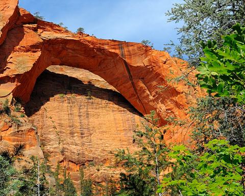
The Kolob Arch Trail
The trail to the Kolob Arch is a short spur trail that takes you north from the La Verkin Creek Trail. The spur trail is only about a half a mile long, making the trip to the Kolob Arch and back to the main La Verkin Creek trail only one mile round trip. The Kolob Arch is well worth that extra mile of travelling. Located on the eastern side of Gregory Butte, The Kolob Arch is over 330 feet wide and is one of the world’s largest natural arches.