The Kolob Terrace:
Zion National Park Hiking Trails
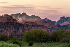
Kolob Terrace in a less traveled region of Zion National Park than Zion Canyon itself. This is one of Klay Klemic's favorite areas of Zion National Park, witha generally higher altitude and a beautiful day trip that is open to private horseback riders. The Kolob Terrace is comprised of the high plateau west of Zion Canyon. In The Kolob Terrace, ost of the hiking trails are less defined, there aer fewer people around and amenities are farther away. The closest town to the Kolob Terrace is Virgin, Ut, which offers very little by way of either grocery or supply so get all your gear and supplies on your way at St. George, Hurricane, if you like to pay high prices for no reason, Springdale. Many of the Kolob Terrace trails close in the winter from November-April due to heavy snows.
The Right Fork
Description: A long day hike that takes you up the canyon of The Right Fork stream to Barrier Falls.
Length: 5.9 Miles
Difficulty: Somewhat Strenuous
Highest Elevation: 5,090 Feet Above Sea Level
Hazards: Possible Flash Flooding
Recommended: Bring a staff for walking in the stream.
Jursidiction: Zion National Park
Length: 5.9 Miles
Difficulty: Somewhat Strenuous
Highest Elevation: 5,090 Feet Above Sea Level
Hazards: Possible Flash Flooding
Recommended: Bring a staff for walking in the stream.
Jursidiction: Zion National Park
Wildcat Canyon Connector
Description: The Wildcat Canyon Connector Trail is a day hike that takes you from the Hop Valley Trailhead to Lava Point.
Distance: 8.7 Miles
Difficulty: Moderate
Highest Elevation: 7,720 Feet Above Sea Level
Jurisdiction: Zion National Park
Distance: 8.7 Miles
Difficulty: Moderate
Highest Elevation: 7,720 Feet Above Sea Level
Jurisdiction: Zion National Park
Northgate Peaks
Description: The Northgate Peaks Trail is a one way hike that takes you to a viewpoint between the Northgate Peaks.
Distance: 2.2 Miles one way.
Difficulty: Easy
Highest Elevation: 6,990 Feet Above Sea Level.
Jurisdiction: Zion National Park
Distance: 2.2 Miles one way.
Difficulty: Easy
Highest Elevation: 6,990 Feet Above Sea Level.
Jurisdiction: Zion National Park
Subway: The Left Fork
Description: This is an overnight hike that will take you into the wilderness area of Zion National Park, where you will rappel down Left Fork Canyon.
Distance: 8.1 Miles
Difficulty: Strenuous
Highest Elevation: 6,990 Feet Above Sea Level
Dangers: Flash Flood Possibility
Required Equipment: 50 Feet of Rope for Self-Rappelling and a wading staff for hiking in water.
Jurisdiction: Zion National Park
Distance: 8.1 Miles
Difficulty: Strenuous
Highest Elevation: 6,990 Feet Above Sea Level
Dangers: Flash Flood Possibility
Required Equipment: 50 Feet of Rope for Self-Rappelling and a wading staff for hiking in water.
Jurisdiction: Zion National Park
Wildcat Canyon
Description: A day hike that takes you into the wilderness area of Zion National Park down Wildcat Canyon.
Distance: 4.7 Miles One Way
Difficulty: Moderately Strenuous
Highest Elevation: 7,720 Feet Above Sea Level
Jurisdiction: Zion National Park
Distance: 4.7 Miles One Way
Difficulty: Moderately Strenuous
Highest Elevation: 7,720 Feet Above Sea Level
Jurisdiction: Zion National Park
West Rim
Description: A Day Hike or overnight trip that takes you from Lava Point through the countryside of Horse Pasture Plateau and down to the floor of Zion Canyon
Distance: 14.2 Miles One Way
Difficulty: Moderately Strenuous from North to South. Strenuous from South to North.
Highest Elevation: 7,720 Feet Above Sea Level.
Dangers: Some Cliff Areas near West Rim Spring
Jurisdiction: Zion National Park
Distance: 14.2 Miles One Way
Difficulty: Moderately Strenuous from North to South. Strenuous from South to North.
Highest Elevation: 7,720 Feet Above Sea Level.
Dangers: Some Cliff Areas near West Rim Spring
Jurisdiction: Zion National Park
Hop Valley
Description: A hike that takes you through Hop Valley to La Verkin Creek.
Distance: 6.7 Miles One Way
Difficulty: Moderate going south to north. Somewhat Strenuous north to south.
Highest Elevation: 6,360 Feet Above Sea Level
Jurisdiction: Zion National Park
Distance: 6.7 Miles One Way
Difficulty: Moderate going south to north. Somewhat Strenuous north to south.
Highest Elevation: 6,360 Feet Above Sea Level
Jurisdiction: Zion National Park